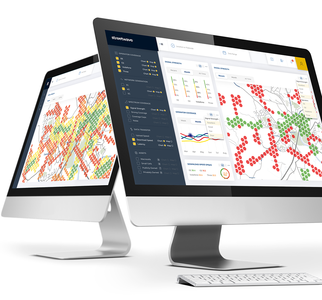
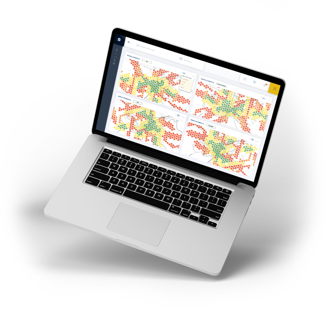
Visualise and Understand Mobile Coverage

Analyse the performance of mobile networks through Streetwave’s data insights and coverage maps

Complete Geographic Coverage

Streetwave’s mapping offers network intelligence at every address, ensuring coverage is understood in rural and urban areas.

Regular Intelligence Updates

New data is collected every week, ensuring insights remain accurate, up-to-date and actionable.
GET IN TOUCH
Streetwave Spectrum Mapping
HM Government
Welsh Government
Alacrity Foundation
Waterloo Foundation
Wesley Clover

What is Streetwave?

We create mobile network performance maps across the UK. These continuously monitor and check the quality of the nation's 2G, 3G, 4G and 5G networks. Streetwave provides coverage, speed and signal quality insights for all major operators including EE, Three, Vodafone and O2.

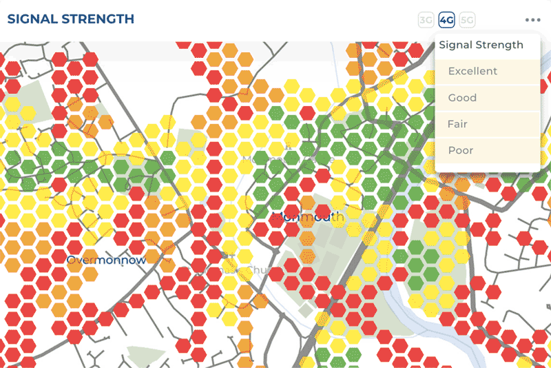
COMPREHENSIVE MAPPING

Our spectrum mapping collects and visualises data readings along all addresses within the areas we map every week.

NETWORK QUALITY MEASUREMENTS

Voice Calls
Email 
Internet Browsing
HD Video Streaming
Other metrics also available & displayed
Streetwave Spectrum Reception

PROTECT CITIZENS

Identify holes in the Emergency Services Network and telecare networks

CONNECT RESIDENTS

Give your residents the intelligence to see which mobile networks keep them best connected

Enhance Mobile Coverage

Speed up infrastructure deployments to connect digitally deprived residents

EMPOWER BUSINESSES

Show your local businesses which mobile network best connects them to customers

REFINE PLANNING

Ensure all new builds are constructed in areas with appropriate mobile coverage

Improve Social Care Efficiency

Keep social care workers connected when out in the field

Empowering Councils with Digital Intelligence

At Streetwave, we provide councils with mobile coverage data to help deliver a wide range of benefits.
GET IN TOUCH

Features 

Streetwave maps mobile coverage to enable better connectivity and planning decisions
GET IN TOUCH

Coverage Analysis

Understand how the mobile networks perform across your council

Mobile Network Comparisons

Contrast operator’s networks to see which has the best connectivity in your area

Network Developments

Identify improvements and deteriorations in the mobile networks over time

CARRIER AVAILABILITY

Visualise how many operators offer coverage in any given area

How Does Streetwave Mobile Network Insights Work?

Streetwave measures mobile network performance and showcases this intelligence on our geographical information system (GIS). You can then use Streetwave to understand the mobile coverage in the areas relevant to you in unparalleled detail. All it takes is three simple steps...
Streetwave 5g coverage spectrum mapping

Step one

Select the area, operator and network type that you want to receive mobile network performance insights on.

step two

Choose how you want to judge the network's performance. You can check to see if calls, emails, internet browsing or HD video streaming can be achieved

step three

Streetwave will then visualise the network’s coverage in a simple to understand format. We ensure you are not tortured with rocket science!

Organise a Call

Get in Touch

We're actively working with councils to create the world's most accurate, geographically comprehensive and up-to-date mobile coverage maps.

Working in collaboration with us, we will map the spectrum coverage of your constituency, examining the mobile network bands in an easy-to-understand manner.

Register your interest in Streetwave, we’ll organise a call and see how we can work together to accelerate and deliver digital connectivity improvements for your residents through data-driven insights.

Streetwave Spectrum Mobile Coverage

Visualise and Understand Mobile Coverage

Analyse the performance of mobile networks through Streetwave’s data insights and coverage maps

Copyright © Streetwave 2024  - All rights reserved.

apartmentcogfile-addgraduation-hatusersmapcalendar-fullsmartphoneheart-pulsepie-chartchart-barslistcheckmark-circle